Showing posts with label Georgia. Show all posts

Saturday, April 18, 2009

On the way to Arizona...

I hit the road today, with Reggie in the co-pilot seat and Missy hiding under the couch.

After a slow start, around 1pm, I left Alpharetta, GA headed for Prescott, Arizona for the first Overland Expo (www.ovexpo.com) where BABS and The Greasy Beast will be on display for a crowd of over 300 attendees. But, more on that when I get there.

Right now it's raining, and I'm sitting in a Flying J parking lot near Olive Branch, in the far Northwest corner of Mississippi, just a few miles outside of Memphis, TN (yes, Memphis is right next to Mississippi.

Having lived the bulk of my life in Georgia, it's natural for me to compare every place I travel to my home state. Not that I think my state is better than any of the other 49, but you have to have some point of reference in order for the world to make sense, and Georgia is my reference.

In that vein, I couldn't help but notice how similar northern Alabama and Mississippi are to North Georgia -- or, rather, how North Georgia used to be. I'm talking about the countryside of North Georgia, just south of the Blue Ridge Mountains, where trees and streams and rolling hills define the terrain. A lot of that terrain has been (or is currently being) developed to accommodate the surge in population and the desire to live outside of the city limits.

Streams are being diverted (or destroyed altogether), lakes and ponds are being filled in, trees are being cut down, and houses and shopping centers are being planted in their place. It all happens so fast that we often don't even see it coming.

My drive through Alabama and Mississippi reminded me of how beautiful Georgia used to be. (Don't get me wrong, Georgia is still beautiful, but it's nothing like it was 20 years ago).

These two Southern neighbors are, as yet, untouched by development (comparitively speaking), and therefore are full of grand vistas of trees, rolling hills, and tiny valleys coming together in narrow streams with overhanging trees and an abundance of green.

In my travels, I've only crossed a few streams in my vehicles -- as most of the bridges I travel upon cross over other roads. But in Alabama and Mississippi, as I headed West over the relatively new Highway 78, there were very few crossroads. Almost every bridge I crossed spanned a beautiful stream or pond that would be completely missed by anyone in a car zipping along at 70mph. (Fortunately, my high vantage point in BABS allowed me to see what everyone else is missing. Unfortunately, because it is a new highway, there wasn't any room to pull the bus over for snapshots.)

It was truly refreshing, and encouraging, to see so much untouched Nature so close to a major highway this far East of the Mississippi River. But, it was also bittersweet... for the current Highway 78 is to be the future I-22.

Yes, another major Interstate Freeway is in the works, and I will tell you right now, that the vistas you see along Highway 78 today will be pockmarked with subdivisions, malls, gas stations, and shopping centers tomorrow.

Catch it while you can folks. It's a Vanishing America.

Monday, March 31, 2008

Rednecks on their day off...

Playin' in the dirt again...

I had a rare opportunity to get away from my work for a day and join my friend Jim on a little redneck adventure. We hopped in his off-road go-cart and raced up and down a gnarly fire road on his property in Dawsonville, Georgia. It had just rained and everything was muddy... including us!

I have to give fair warning, though. This isn't exactly environmentally friendly driving. And, on the surface, may seem to contradict what I'm doing with my Vanishing America project. However, it was a closed course specifically designed for this kind of fun, and we didn't destroy anything in the process (except for one of Jim's daffodils). It was a blast, and an invigorating experience. We got to be kids again for a couple of hours.

I'm still scraping mud off my teeth.

I'm posting the video from my YouTube page. I hope it works here.

Thursday, March 06, 2008

University of Georgia


For those of you who are University of Georgia Alumni, check out the latest issue of Georgia (the Alumni magazine). Don't just toss it out!

I haven't seen it yet, but there is a short piece on the Vanishing America project in this month's issue.

Maybe this will pique the interest of some alumni who are looking for a new project to fund... :-)

We could sure use it!


For sponsorship ideas or donations to the Vanishing America project, contact Holt at holt@vanishingamerica.net

Wednesday, November 01, 2006

Okefenokee National Wildlife Reserve


Okefenokee Swamp National Wildlife Reserve, Georgia

Day 1 -- October 21, 2006

Drove from Atlanta to Folkston, GA. I passed through some really interesting small Georgia towns on the way south. There are definitely some photo opportunities along the way. It would require a leisurely sojourn with no timetables, no deadlines, and no expectations. Just plain and simple exploring and visiting.

Got in to Okefenokee Pastimes (www.okefenokee.com) at about 9:30pm. Just enough time to check in to my cabin and hit the hay.

Day 2 -- October 22, 2006


Have the whole day to myself to sleep in, explore, and get a feel for the area. Because I arrived so late the night before, I slept until 9am. Unfortunately, I tossed and turned all night, so I didn't get much rest.
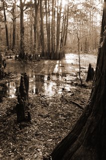
I drove into Waycross to get a few items that I needed but didn't have room for in my pack gear and stopped off at a few spots along the way to scout photo locations.

The first stop was Kingfisher Landing. It's a great entry point into the channels of the Swamp -- if you have a boat. Otherwise, there are no trails and no means to get around.

Afterward, I drove to Trader Hill. It's a recreation area with a boat dock on the banks of the St. Mary's River. It's a great spot to put in. It doesn't take you into the Swamp, but since the river is part of the same ecosystem, it shares some of the same characteristics. Steve and I will try this area later in order to get to some of the sloughs (pronounced "slews") that meander like fingers off of the river proper.

After my scouting expedition, I meandered back to the Refuge entrance, right across from my campsite at Okefenokee Pastimes. I drove the island road onto Chesser Island and parked at the trailhead (actually a 1 mile boardwalk) leading to Owl's Roost Tower. The mile hike to the tower is pleasant, unless, like me, you have a 75lb pack full of camera gear strapped to your back. Let me tell you, it was a tough walk.

I arrived at the tower about an hour before sundown. I shot in black and white and in color with my Hasselblad, my Nikon F5 and my Nikon F3 (loaded with infrared film). I even snapped a few with my 1936 Zeiss Super Ikonta. I was in the perfect place overlooking the prairies of the swamp and the tiny, but beautiful, Seagrove Lake while the sun cast it's colors across the cloud formations and the blue backdrop of the sky. There was only one problem... the park locked their gates at 7:30. It would take me 15 minutes to hike the mile back to the car, then another 10 minutes to reach the park gate before they locked me in. And the most vivid colors in the sky wouldn't come until about 7:15. So, in order to get out in time, I had to cut the sunset short and hoof it back to the car (remember, I'm carrying a 75lb pack) and book out of there as quickly as I could. The whole time I'm looking back over my shoulder at that gorgeous sunset wishing I'd waited to take my trip until after Eastern Standard Time kicked in.

And, to my great disappointment, I wouldn't see another sunset like that for the rest of my trip. Next time, I'll make sure to go after the time change so that I can be guaranteed to still be allowed in the park after the sun goes down.

Day 3 -- October 23, 2006

Today is my first guided tour into the swamp. I got up at 6am (about an hour before sunrise) so that we could be on the water by 7:30. It was quite chilly, but very peaceful.

Rather than take a canoe, we took a flatbottom boat with a small outboard and a trolling motor so that we would have enough room for my camera gear and a place to set up a tripod. We were the only ones on the water, silently motoring through the channels that carved into the prairie, watching the sun rise over the cypress in the east. Even though the water was still, my exposures were long enough that we had to stabilize the boat by edging it up onto a peat bog.

I got some fair shots of the prairie with the sun peeking through the trees, but I had to fight a little bit with a cool breeze that was coming up and with the sun playing peek-a-boo through the clouds.

We circled the center of the prairie then worked our way further into the swamp via the canals searching for overhangs of cypress and spanish moss. The backlit moss and the pollen on the surface of the water allowed for some good shots in one of the channels looking straight into the sun. I actually had to settle my tripod into the water, sinking the legs several inches into the mud, just to get a steady shot. (I wish Steve had taken a picture of me leaning over the bow of the boat lining up my shot with my Hasselblad just inches above the tea-colored water.) When the wind died down, and the sun rose high enough, I was able to use my monopod on the bow of the boat to get a steady enough shot.

Day 4 -- October 24, 2006

In the morning, after sleeping in a little bit, I hiked a couple of trails at the East entrance to the Park. Lots of gators, but not much else. Because the water level of the Okefenokee was so low, the whole area at the East entrance seemed more like a lowland forest than a swamp.

During the afternoon, I set out to Chesser Island on foot via the Ridley Island Trail. It's about 2 1/2 miles from the trailhead to the Chesser Homestead. Again, with adequate rainfall, the trail would have borne some resemblance to swampland. As it was, it seemed more like a hike through the woods.

When I got to the Homestead, it as very quiet, very empty, and had a deserted feel to it. It was as if the family tidied everything up, put all their stuff away, and just left. Kind of spooky. One of the things that really enhance the deserted feel was the grounds themselves. The whole of the Homestead property was freshly swept hard-packed white sand with a few scattered Cypress (which is what constitutes much of Chesser Island). I was told that the idea behind keeping the grounds so clean is to keep the Pygmy Rattlesnakes off the property. The snakes don't like the white sand because it gets hot in the sun, and it's very bright. The contrast of the white sand also makes the dark-colored snakes easily visible.

The effect of the Homestead was surreal. These shots were done in infrared to enhance that feeling.

After I returned from Chesser Island, Steve and I went out on the St. Mary's river to try to get some more shots. We put in around 4pm, tooling around until sundown. The river itself is beautiful and peaceful, but not very swamp-like. However, we took the boat into the sloughs -- the small, backwater offshoots of the river -- where there are some very picturesque areas of near complete solitude. Sometimes the sloughs go for a mile or more, and sometimes they barely draw out 50 yards. Most meander slowly through dense overhangs of Cypress, Pine, and Oak, often ending in a cul-de-sac pool of almost-still water covered over with blankets of lily pads. These sloughs provide homes to countless fish, waterfowl, and, of course, alligators. But, not to worry. The gators on the river are much more shy than the gators in the swamp, so the chances of actually seeing one are pretty slim. As a matter of fact, we didn't see a single alligator on the river (compared to one every 50 feet or so in the swamp.)

Deep into the sloughs, the tranquility is almost tangible. During the cooler months of September and October, it would be an ideal camping spot. Nobody around, easy fishing, fresh water... an outdoorsman's paradise.

And, one of the most contrasting, but interesting parts of the river were the beaches. Yes, there are beaches on the river. The inside of some of the curves of both the river proper and the sloughs have clean white sandy beaches. (Just another reminder of how close to the ocean you actually are.)

That evening, as I sat at my cabin cooking some chili for dinner, I met a nice young couple from Germany, Julia and Ulf, as they were moving into the cabin next to me. We sat at the table, had some beer and wine, talked politics, social patterns, cultural norms, etc., and had a great time. They were very intelligent, and the conversation was stimulating. It was a good change of pace from the self-imposed solitude I'd been experiencing for the past few days.


Day 5 -- October 25, 2006

I got up around 6am, packed my gear, and hurried down to the Owl's Nest Tower to try and catch the swamp's prairies nestled in the fog. Had I waited to pack until after I took the photos, I would have gotten some great shots to add to my Fog series. As it was, I was too late, and the sun had already burned the fog off the water. Next time: shoot first, pack later.

After the Tower, I drove straight to St. Mary's, a little town on the Georgia Coast, and hopped on the ferry to Cumberland Island. You can pick up on the Cumberland Island part of my trip in the following entry.

Monday, September 04, 2006

Development on Cumberland Island


Development on Cumberland Island?

There is a proposal out now by the National Park Service to improve access to the North end of Cumberland Island, just off the coast of Georgia. There is great debate about the plan centering around the impact of increased public access.

The basics of the plan can be found on the NPS website by clicking on the link below.

External Scoping - Cumberland Island National Seashore Transportation Management Plan:
http://parkplanning.nps.gov/document.cfm?projectId=16447&documentId=16171


Since I will be travelling to Cumberland Island in October (to document the wildlife and uninhabited natural beauty of the seashore), I am very interested in this discussion. The intent of the plan, if implemented, would be to improve access to the North end of the island by providing additional transportation on the existing dirt roads (unfortunately, many people take that to ultimately mean paved roads and all the necessary facilities that humans will need during their tours -- ie: restrooms, food, running water, electricity, parking, information booths, signage, etc.)

I'm all in favor of people seeing this beautiful country of ours, but I'm not in favor of the changes that must take place in order to make areas accessible.


Here's my beef:

What most people fail to understand about granting access to wildlife and nature is that the very accessibility you create compromises the natural state of the environment you are visiting.

People and wildlife have flourished for generations on Cumberland Island. Why? because they didn't have civilization crowding in on them, forcing them to join in on the Industrial Revolution. The roads that are planned, even if it is as simple as grading the existing dirt roads and paths, will facilitate more movement across and around the island, allowing more people to get from point A to point B. And more poeple means more facilities for those people (bathrooms, parking, food, garbage collection, running water, electricity,etc.). It's an inevitiable progression. And, on an island as small as Cumberland, it will have a serious impact.

People have every right to enjoy the park, but if access is increased, the park will change. And it will NOT be the same park you see today.

It's a basic rule of Quantum Physics. The mere act of observation affects that which is being observed.

And that is the bottom line...

Once you allow access to a place, any place, you change the dynamics of that place and it will never be the same again.


Many people complain about how difficult it is to get around the island. Well, it's difficult to get to the top of the Great Pyramid, too. It's encouraging that people are interested in nature and want to see the island, and it's great that the National Park Service wants more people to see it, but providing a shuttle service to the north shore will diminish the natural qualities of the island. There are already several options for people willing to make the effort (bicycles, hiking, the Greyfield Inn's own tour bus). And, it should take effort to get there -- it's not Disneyland, it's wilderness.

One of the arguments, to quote a blogger on Peach Pundit, is that the Island's "current system discriminates against the elderly, the disabled, and those who do not have a propensity to walk 35 miles round trip."

I know it may seem harsh, but if you have physical ailments or disabilities that prevent you from making the trek around Cumberland Island, or you just don't feel like walking, then you'll have to do the exact same thing you'd have to do if you wanted to hike the Grand Canyon, climb Kilamanjaro, or swim the Great Barrier Reef: tough it out. (Or maybe we should provide shuttle service to those places, too?) I'm sorry, but we just can't make everything accessible to everybody.

What seems to be the real issue at hand, what seems to be at the heart of why people are taking sides on this issue in the first place, is this...

Will improved access hurt the island?

I agree that every citizen has the right to enjoy the Park, and you have the right to request improved access. But if you do, no matter how you look at it, it will NOT be the same park you see today. I, personally, don't want to see the island change. But that's just one person's opinion. There are thousands of other opinions to be heard and weighed. And the majority will rule. So, be careful what you wish for -- once all the Americans with Disabilities Act (ADA)-approved services are implemented, and access is increased, Cumberland Island will be a very different place.


You can follow some of this debate at http://www.peachpundit.com/2006/08/24/transportation-on-cumberland-island/


www.holtwebb.com
www.myspace.com/holtwebb
© Holt Webb Photography